")
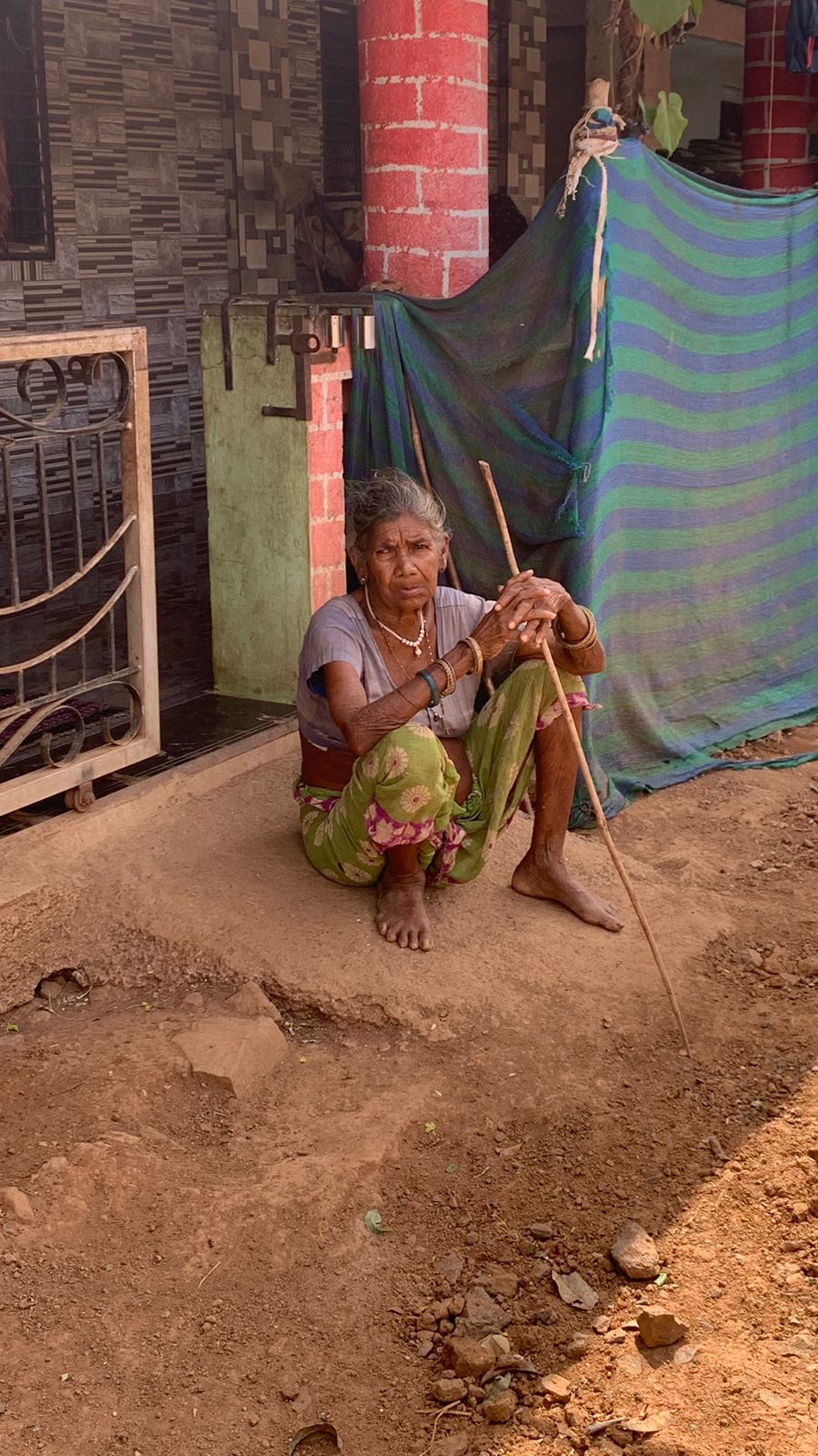
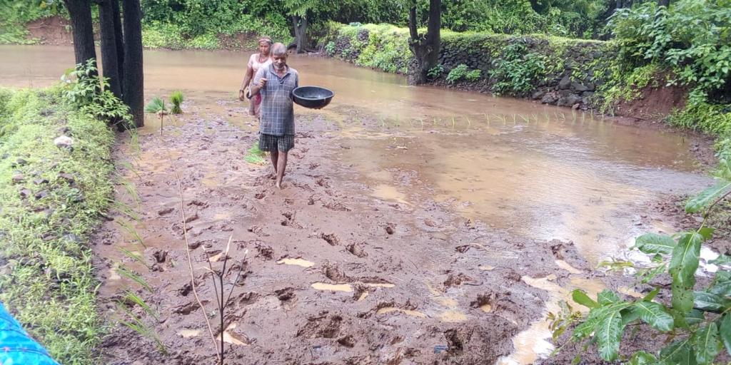
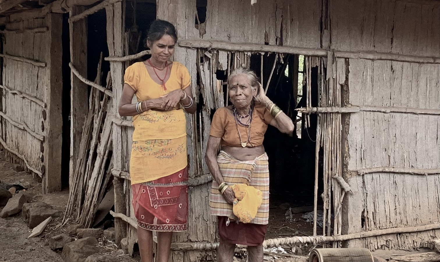
During the summer between my 9th and 10th grade, I had the incredible opportunity to visit India, my family’s homeland. Witnessing the challenges faced by rural farmers firsthand was a transformative experience. As I traveled through various regions, including Mokhada in Maharashtra, the stark reality of farmers losing their cultivable land became evident. These eye-opening encounters fueled my determination to get involved. It was not just a project anymore; it became a personal mission to leverage technology for positive change. The time in India ignited a passion within me to contribute to the well-being of the communities I had connected with on a personal level.
This experience served as the catalyst that propelled me to embark on the drone project, aiming to empower farmers and provide them with the tools they needed to thrive in their agricultural endeavors. The project found a powerful ally in the Raah Foundation, a Non-Governmental, Non-Profit organization affiliated with the United Nations (https://www.raahfoundation.org/). Together, we connected with farmers in Mokhada, Maharashtra, gathering invaluable insights that would shape the project and cater specifically to their needs. Imagine a drone taking off, capturing images of farmland, and using computer vision to highlight cultivable land. That was the vision. The drone’s pre-planned flight path aimed to provide farmers with actionable information to improve their yield and make informed decisions. As we conclude this first chapter, the journey from realization to action has been inspiring and transformative. What started as a heartfelt response to the challenges faced by farmers in rural India has evolved into a mission to empower them with drone technology.
To begin the build, potential solutions were brainstormed:
Intelligent Drone:
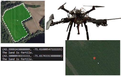
An intelligent drone will perform a sweep over a parcel of farmland, and use its camera to take images during the sweep. A computer vision algorithm will be applied to the images to determine where fertile land (if any) is.
Algorithms Using Satellite Imagery:
An algorithm will be applied to pre-existing satellite imagery of a parcel of farmland to determine where any fertile land (if any) is.
Ground Vehicle With Sensors:
A ground vehicle will drive over land and use sensors at different points to collect information. The information will be used to determine whether the land around that point is fertile.
The “Intelligent Drone” solution was chosen for three main reasons. First, it is easy to use as the ground vehicle would require monitoring to make sure it doesn’t get stuck. Secondly, the drone is much quicker than the ground vehicle, as it can cover more ground faster. Finally, the drone has much better data quality and resolution than satellite imagery and the ground vehicle. The scope of this project is to test the concept and develop a minimum viable product to do the following:
- Perform a sweep over farmland.
- Take images of the farmland.
- Show the farmer where fertile land is.
Researching Existing Drones For Agricultural Use:
Existing drones for agricultural purposes were researched. The main options are listed below:
- DJI Agras T40–$19,999
- DJI Matrice 210 RTK V2–$12,000
- DJI Matrice 300 RTK Agriculture–$24,999
Finding a Programmable Drone:
When looking for a drone that could possibly be used for this project there were 5 options that were found. They are listed below:
- Parrot AR Drone
- DJI Mavic 3
- Skydio 2
- Ryze Tello
- Custom-Built Drone
Choosing the Best Programmable Drone:
The pros and cons of each drone and a weighted average table were evaluated to determine the best drone for the project.
Parrot AR Drone:
Pros:
- Able to move at high speeds.
Cons:
- The Parrot AR Drone is not widely available, so it can only be purchased on the used market. As a result, there are not many users creating solutions, hence a lack of community support. This support comes in handy when there is an issue with a program and debugging is required or to understand any limitations with the drone itself.
DJI Mavic 3:
Pros:
- DJI is a reliable brand and is the most well-known brand in the consumer and commercial drone space.
- If anything goes wrong with the product, it is easy to get customer support and repair solutions.
Cons:
- It is very hard to program this drone because there is no way to take the frames from the drone’s camera and process them.
- DJI has not opened its hardware for open-source development.
- Additionally, this is an expensive drone.
Skydio 2:
Pros:
- It has exceptional built-in tracking software that uses a tracking beacon and six obstacle-avoidance sensors to track a subject at high speeds while avoiding obstacles.
Cons:
- This drone has the same issue as the drone above as it is hard to program, and there is no way to process the frames.
- The drone also cannot easily map terrain.
- Additionally, this was an expensive drone.
Ryze Tello:
Pros:
- This drone takes technology from DJI for components like the motors, propellers, and design.
- It also uses an onboard intel processor to perform tasks, like computer vision.
- It is very cost effective, priced at 125 dollars.
Cons:
- It is not suited for proper outdoor use. Also, since it is very cheap, problems could occur with the calibration and use of the drone.
- This drone is also not suitable for outdoor use.
Custom-Built Drone:
Pros:
- Building a drone from scratch allows the user to customize the parts used, meaning the user can customize the capabilities of the drone.
- Additionally, since only the necessary parts are purchased, the drone is much cheaper than other options.
Cons:
- As parts are purchased individually, there is a high chance of incompatibility
A table was created to evaluate which drone was the best for the project, as we had many good options.
| Criteria | Weight (1-10) | Parrot AR Drone (1-10) | DJI Mavic 3 (1-10) | Skydio 2 (1-10) | Ryze Tello (1-10) | Custom Drone (1-10) |
| Ability to Apply Computer Vision | 10 | 2 (20) | 8 (80) | 2 (20) | 7 (70) | 9 (90) |
| Easy to Use | 5 | 3 (15) | 6 (30) | 7 (35) | 4 (20) | 9 (45) |
| Ability to Customize | 6 | 2 (12) | 1 (6) | 1 (6) | 2 (12) | 10 (60) |
| Developer Community | 4 | 1 (4) | 0 (0) | 0 (0) | 6 (24) | 9 (36) |
| Price (Higher is cheaper) | 4 | 5 (20) | 3 (12) | 4 (16) | 9 (36) | 7 (28) |
| Battery Life | 1 | 2 (2) | 10 (10) | 8 (8) | 5 (5) | 9 (9) |
| Ability to Map | 10 | 2 (20) | 5 (50) | 3 (30) | 2 (20) | 9 (90) |
| Total | 17 (93) | 33 (188) | 25 (115) | 35 (187) | 62 (358) |
We then developed a list of requirements:
Endurance requirement (Distance, flight time):
400 ft vertical, 20 minute flight time.
Payload Capacity:
Up to 500 grams of payload capacity for a camera and possibly a gimbal.
Stability:
The drone should be able to maintain enough stability with the possibility of a gimbal to keep the camera level to take a high resolution images of the field.
Weight requirement:
5 pounds or less.
Camera resolution:
At least 720p.
Safety (If it loses communication with ground station, if it loses GPS):
If it loses communication with the ground station, it should automatically return to its starting point. If it loses GPS, it should emergency stop all propellors.
Water proofing/Dust proofing:
It must be dust resistant, as dust can be kicked up upon takeoff and landing, but no water proofing is required.
Transmission:
There should be a telemetry link as well as a radio link to the drone.
Auto take-off/landing:
The drone should use an automatic takeoff as well as automatic landing.
Should the user have the ability to take manual control:
No.
Intuitive interface (live feed and gps, press a button and bring it back):
Yes, there should be a dashboard that provides a live feed from the gps, camera, and give the farmer the ability to schedule when to do a sweep, do a sweep now, and an emergency stop.
Durability/Materials (Carbon fiber):
The drone should be very durable and resilient through crashes, as well as light.
Onboard processing capabilities:
PX4 should be used to automate taking a picture or performing a sweep.
Size (Folding capabilities):
Doesn’t need to fold.
Permanent ground station:
Yes, a designated computer or mobile device.
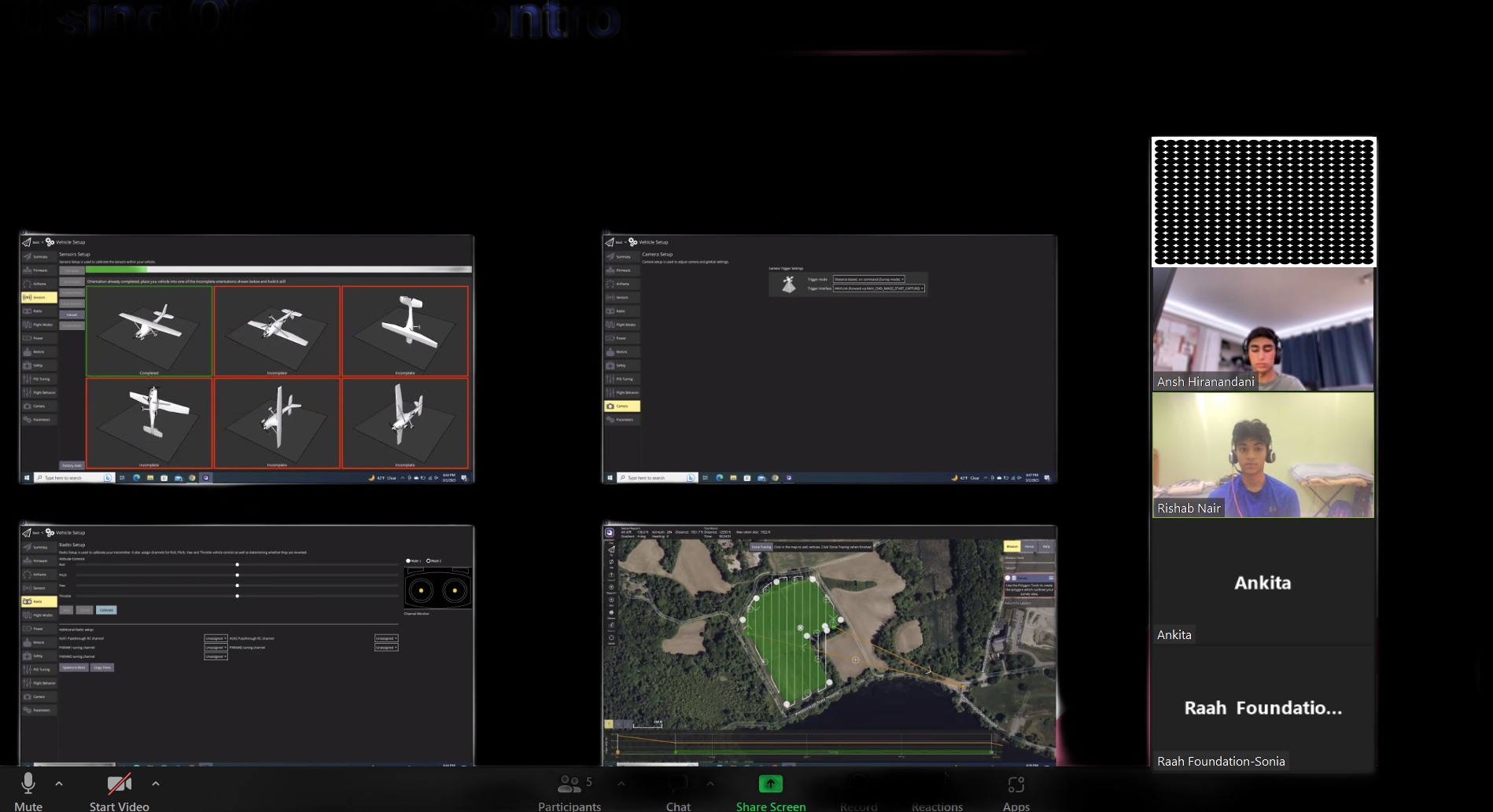
After making the list, it was determined that we would need a quadcopter with a Raspberry Pi and PixHawk.
4 Responses
Dear Ansh, your selection of the project and its meticulous execution is truly commendable. We are very proud of you. You have always been an exemplary student and we at MathAltitude believe in your very bright future as you go to college and beyond. We wish you lots of success in all your future endeavors!
Ansh Hiranandani That’s truly commendable! Your efforts to assist rural farmers in India by determining farmland fertility and improving crop yield are making a significant impact. The fact that an article was published in the Community Advocate to highlight your success speaks volumes about the positive change you’re bringing to the community.
Your blog about AI-equipped drones is a valuable resource for others interested in sustainable farming practices. Keep up the great work, and I hope your efforts continue to benefit farmers and their livelihoods!

Your determination to positively impact the lives of rural farmers in India through your initiative is incredibly inspiring. Your unwavering dedication to conducting thorough research as the cornerstone of your project is truly commendable. Keep up the exceptional work!
It is indeed inspiring to see young minds like you are taking initiative to make a difference in the lives of others, specially the rural farmers of India. Your commitment to thorough research as the foundation of your project is truly commendable. Keep up doing good work.